FAQs & Trail Tails
Frequently Asked Questions
General
Blank
Can you tell me some of the history of the Roanoke River?
How should I go about planning my trip on the paddle trail?
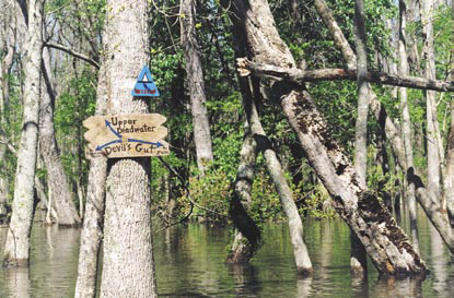
Campsites: All of our campsites are primitive. What does this mean? It means that there is no running water, electricity, or flush toilets. It means getting back to nature! Some of our sites are on the bank of the river (Ex: Tusca, Tillery, The Bluffs, River Landing). You can reach these by land or water. The others are only available by water thus you’d need a boat to reach them. (Ex: Conine, Barred Owl, Beaver Lodge/Tail, Three Sisters, Cypress Cathedral, Cow Creek, Bear Run, Royal Fern, Lost Boat, John’s Island, and Holladay Island). Some are open deck with no shelter and others have a roofed shelter. Those with a roofed shelter are: Tusca, Tillery, The Bluffs, River Landing and Conine. Be sure to read the detailed description for each site.
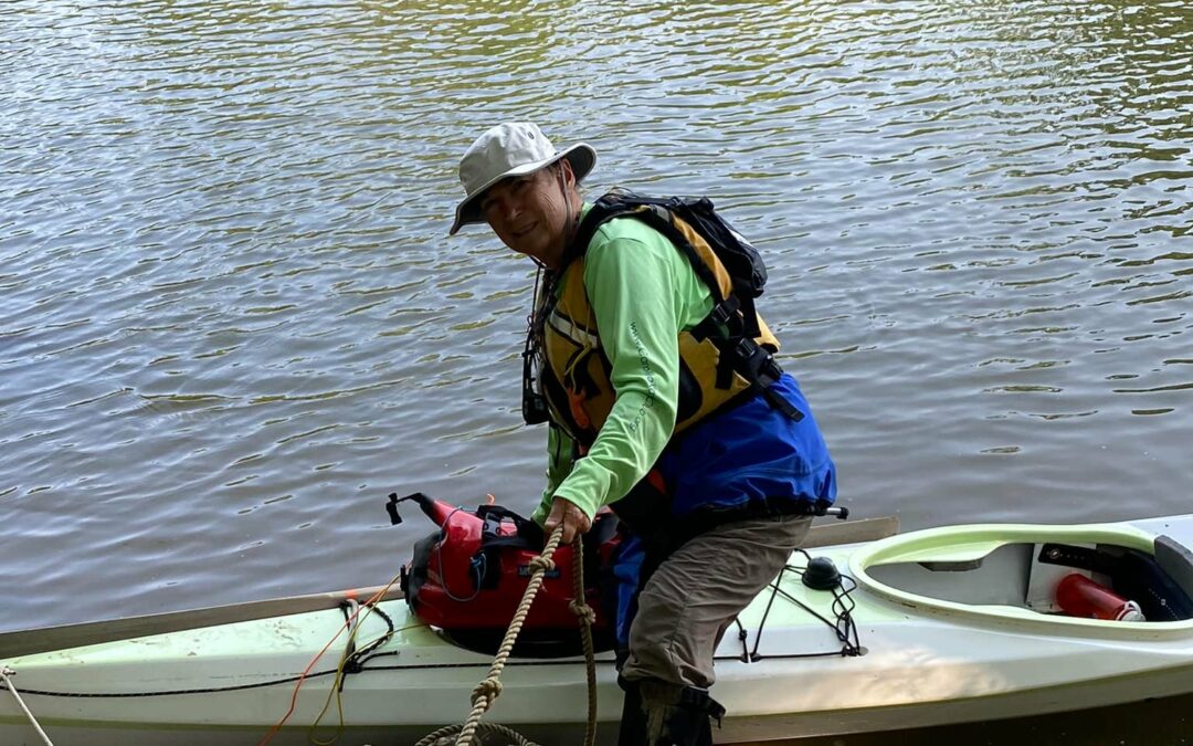
The next step is to make an honest assessment of your paddling abilities. If you’re a beginner, we suggest you consider hiring a guide. Beginner to intermediate paddlers may also wish to opt for creek rather than river paddling and plan for shorter distances between stops. Creek routes are preferable if you haven’t paddled with a river current before. If you do take the river, plan a downstream route unless you’re a strong paddler who has paddled upriver before. Check river flow. Check weather reports for the area you are interested in paddling, And always pack your safety items first! Bring a good-fitting personal flotation device (PFD) for each person to WEAR on the water. Even if you can swim wear your PFD, you never know what may happen. Include a cell phone (although it may not receive a suitable signal at all points along the trail), first aid kit, water and snacks, sunscreen and bug repellent. Good first overnight trips for beginners to intermediates include Beaver Lodge or Barred Owl Roost (by way of Gardner’s Creek and Devil’s Gut) and Royal Fern (by way of Conaby Creek). More advanced paddlers will enjoy paddling the Roanoke to Conine, Bear Run or one of the Broad Creek camping platforms – Cypress Cathedral, Cow Creek or Three Sisters. Or try paddling the Cashie to Lost Boat or Otter One. Examples of two night stays with no need of a shuttle: 1) Barred Owl Roost and either Cypress Cathedral or Three Sisters on the loop; 2) Lost Boat to Otter One. Lots of trip options available. Feel free to email us or call for questions! See additional trip planning advice.:
Where can I get a map of the Roanoke River Trail System?
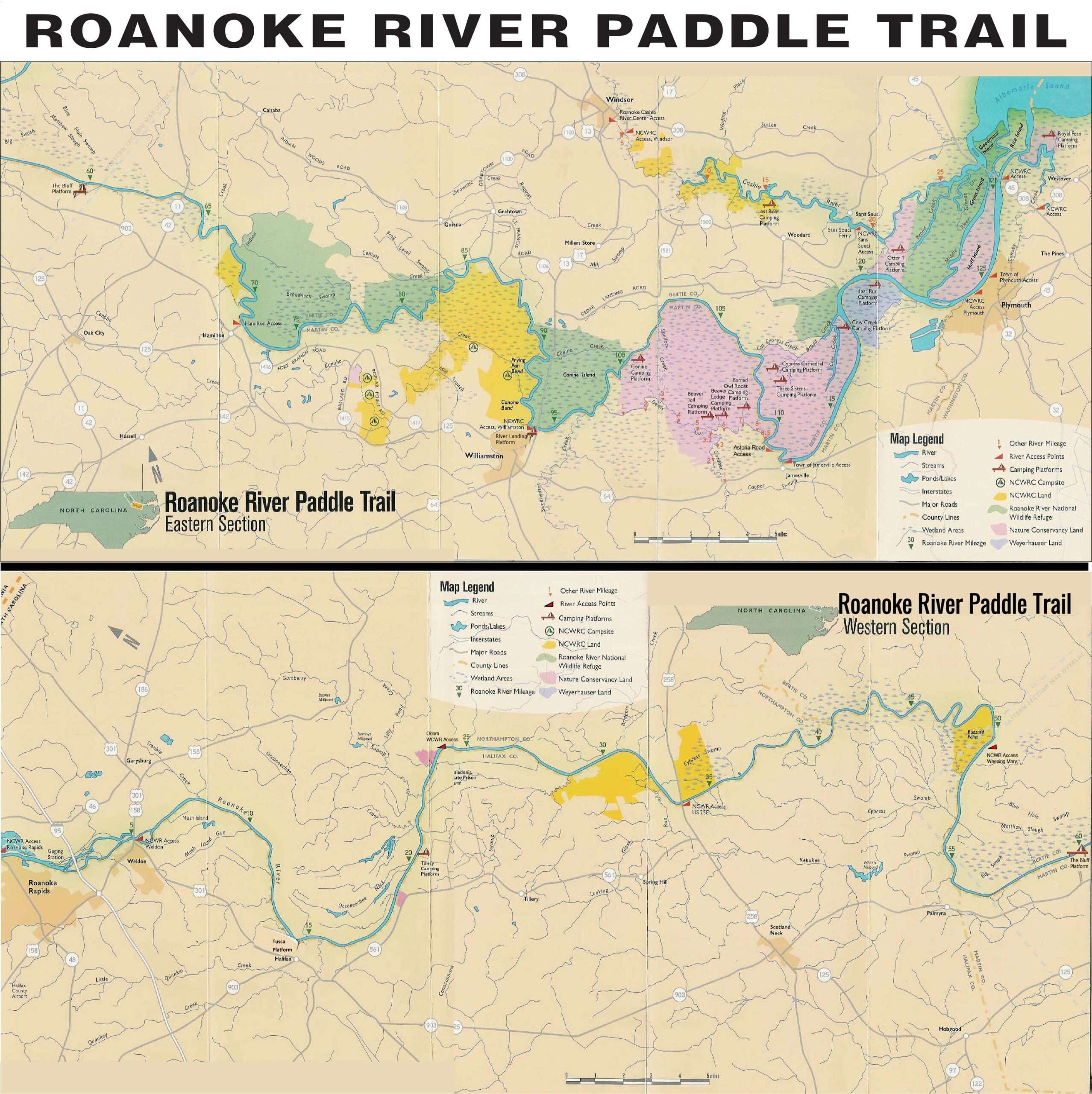
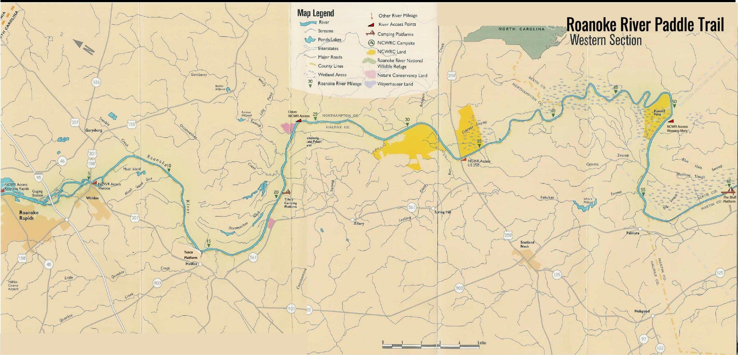
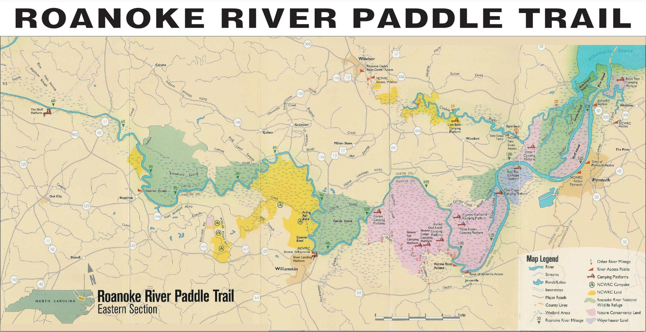
We don’t offer printed copies of a Roanoke River map, but you can download the digital version and print it for your use. You might consider laminating it with contact paper so it’ll stay dry on your trip. See separate FAQ for Cashie River. See Platform Descriptions or google maps for Bertie Beach and Chowan County platforms. See list of accesses under FAQ as some “kayak only” launch sites are not shown on this trail map.
Roanoke River State Trail – Overview
Roanoke River Paddle Trail Map – Roanoke River, Cashie River & Chowan regional map
Roanoke River Paddle Trail Map – upstream and downstream – Roanoke & Cashie River only
Roanoke River Upstream Paddle Trail Map – Roanoke River only
Roanoke River Downstream Paddle Trail Map – Roanoke & Cashie Rivers only
Do you have helpful links for water flow, weather, and other resources?
NC Department of Environment and Natural Resources
North Carolina Wildlife Commission
Do you have suggestions where I can find local tourism information?
Are mosquitoes and other biting insects a problem?
Is there a bird list for the Roanoke River?
What can you tell me about the river basin?
The area is home to black bear, river otter, white-tail deer, bobcat, beaver and mink. Over 200 bird species have been identified including bald eagles, barred owl, osprey, and anhinga. Coupled with the hundreds of great egrets and great blue herons nesting in the region, it is a birdwatcher’s paradise. The River is renowned for its abundance of striped bass, largemouth bass, black crappie, lunker catfish, gar and bowfin. Just above the waterline, turtles sun on logs near the banks.
For thousands of years, dugout canoes have been the ultimate vehicle to explore these amazing waters. In this spirit, RRP volunteers and contractors have constructed trails and camping platforms in the Roanoke River backwaters offering a swamp experience unlike any to be found in the Mid-Atlantic 200-mile wilderness eco-adventure for people of all ages. The Trail System features a series of water-bound camping structures that allow paddlers to overnight in some of the amazing water jungles of NC’s coastal plain. Although the trail facilities are developed, built and managed by Roanoke River Partners, many are located on environmentally sensitive wetlands. The partnership between landowners is an excellent example of how RRP can bring together different interest groups for the benefit of all. (Paddle the Mighty Roanoke, Wildlife in NC, by Ida Lynch)
Where are the Roanoke River Region Boating Access Points?
List of Roanoke River State Trail boat/trailer accesses AND canoe/kayak accesses are shown here. Our trail map shown above in FAQ shows public boat/trailer access and does not show canoe/kayak only accesses which are shown on this list. The trail map shown above does not show the Chowan County (John’s Island or Holladay Island) or Bertie Beach sites which you should google map.
Overnight Stays
Blank
Where can I obtain boat rental, shuttle or guide service?
A few options for consideration:
Albemarle Fishing Charters – Boat trips and tours. website: albemarlefishingcharters.com. Call 252-333-6524 or email: info@albemarlefishingcharters.com.
Cardinal Canoes – Buys and sells used canoes and kayaks. Serving eastern NC. Call 252-752-0697 or email: dcschwartz@hotmail.com.
Frog Hollow Outdoors – Provides residents and visitors of the Triangle and North Carolina a resource for canoe and kayak education, the exploration of nature, relaxation, adventure, self-discovery, and a greater overall connection with the outdoors. website: https://www.froghollowoutdoors.com. Call 919-416-1200 or email: info@froghollowoutdoors.com.
Harbour Masters Office – Boat rentals and other additional services for the area. 103 W Water Street, Edenton, NC. Call 252-482-2832 or email: edenton.harbor@edenton.nc.gov.
Inner Banks Outfitters – Kayak rentals. 1050 E. Main Street, Washington, NC. Call 252-975-3006 or visit https://www.innerbanksoutfitters.com/rentals.
Lake Gaston Outfitters – 2401 Eaton Ferry Rd, Littleton, NC 27850. Call 252-586-1770 or email: info@lakegastonoutfitters.com.
Native Girl Kayaking – Offers kayak rentals and guided trips. Will deliver and pick up boats. website: nativegirlkayaking.com. Call 252-404-2266.
River Vibes – 108 S. Market Street, Washington, NC – Offers kayak rentals. Pick up in Washington or work with them for delivery. website: https://rivervibes.wixsite.com/smoothiesandrentals. Call 252-947-5824 or email: rivervibesonthepamlico@yahoo.com.
Roanoke Cashie River Center – Science, art, nature and history come together for a great experience for the visitor. Boat rentals are offered. 112 W Water Street, Windsor, NC. website: https://www.partnershipforthesounds.net/roanokecashierivercenter Call 252-794-2001 or email: rcrckayakrentals@gmail.com.
Shuttle Service: Williamston, NC – Gainers Taxi: Call Pete: 252-799-7730
To avoid the need for a shuttle: Consider the loop paddle from the Roanoke River up Broad Creek (Three Sister, Cypress Cathedral, or Cow Creek platform region) and back.
Do you have any information about the Cashie River?
Do I need to make a reservation to camp on a platform?
How many people can camp on a platform?
When is "Check Out" and "Check In" time for the campsite?
Can I paddle upriver?
Can I fish on my trip and are there any regulations I must follow?
Are guns allowed on the platforms?
Can I rent a canoe or kayak once I'm there?
What kind of kayak should I use on the Roanoke--sit-on-top, open or skirted?
What should I do if walkways to the platforms are flooded?
How far up or down the Roanoke can I navigate?
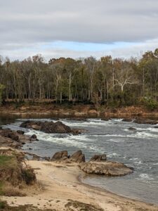 The river is navigable from Weldon to the Albemarle Sound and from Roanoke Rapids to Weldon if dam releases are about 7000 cfs or greater. Be aware that the river flow in this area can change drastically and quickly because of power production releases from the dam at Roanoke Rapids. Local fishermen (familiar with navigation in this area) use the river at much lower levels but they know where the rocks and rapids are! The river is navigable from the NCWRC boat landing in Weldon at Hwy 301 all the way to the Albemarle Sound. Some creeks and shortcuts may not always be navigable due to downed trees or other obstructions. (Picture shows rapids at Weldon – height varies)
Is the water tidal?
Can I use a water filtration system to filter river water rather than having to carry all my drinking water?
Are there any rapids along the Roanoke?
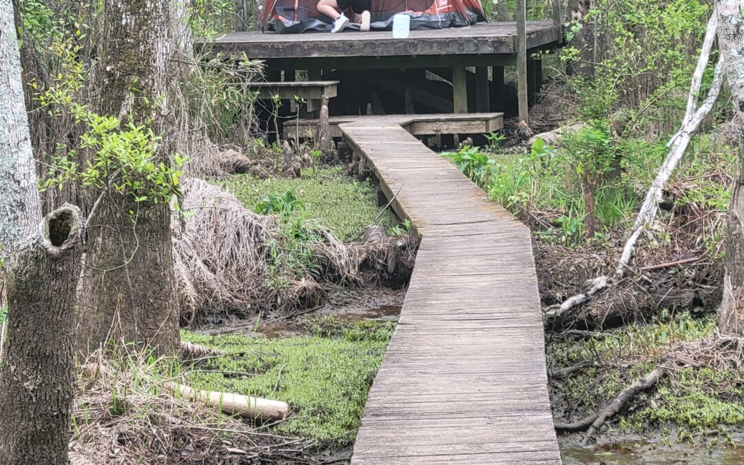
What is platform camping like?
Platform camping is primitive camping in an isolated setting – and an excellent way to enjoy the many habitats of the Roanoke. You’ll be surrounded by nature, so bring your camera or your sketchpad! You will bring everything you need in your canoe or kayak, so pack light. Roanoke River Partners asks that campers adhere to a strict “pack it in, pack it out” policy. The “Leave No Trace” policy includes carrying your camping toilet and carrying ALL wastes back to land for proper disposal. (Tip: Porta-Potties–or even a 5-gallon plastic bucket–can be lined with heavy duty plastic bags containing a small amount of kitty litter to absorb liquid wastes and help with odor control.) Be sure not to leave any food wastes, as well, since food can cause problem with, and for, wildlife. Please… leave no trace of your visit when you break up camp. Here’s a tip from one of our campers: Our portable latrine – a 5-gallon bucket, a pool noodle cut for a seat (quite comfy I might add), and some toilet kit waste bags (each kit contains 1 waste bag; Poo Powder® gelling/deodorizing agent; a zip-close storage bag; toilet paper; and a hand wipe). We bring our own toilet paper and some cleaning wipes. We stash the sealed waste bags in a trash bag and dispose of it when we reach land (these kits are approved for landfill disposal)…now you know.
What safety gear should I pack?
What should I bring on my camping trip?
Useful items include a pop-up tent (must be free-standing and we recommend that you have one with good screening) and/or a tarpaulin, food, bedding, a camp stove if you want to cook (NO CAMPFIRES are allowed at platform campsites, even on nearby dry ground UNLESS SPECIFICALLY DESIGNATED AT THE CAMPSITE AND ONLY IN THE FIRE RING PROVIDED), water for drinking and sponge baths, sunscreen, insect repellent, a first aid kit and cell phone (although a useable signal may not be available at all points along the trail). You MUST bring your own camping toilet. If you do not have a camping toilet, you can use a 5-gallon bucket with a lid, fitted with a heavy-duty plastic bag (a trash bag works.) Kitty litter helps absorb odors. ALL waste must be disposed of properly when paddle trips are over. DO NOT dump waste at or near platforms! There is NO running water or electric hookup on platforms. We try to keep a broom on the platform but you might consider bringing one as sometimes they disappear. All food and debris should be stored in air-tight bags or containers so as not to attract bears or other animals. Bears are prevalent around some platforms and this warning must be taken seriously!
Here’s another tip from one of our campers: Our portable latrine – a 5-gallon bucket, a pool noodle cut for a seat (quite comfy I might add), and some toilet kit waste bags (each kit contains 1 waste bag; Poo Powder® gelling/deodorizing agent; a zip-close storage bag; toilet paper; and a hand wipe). We bring our own toilet paper and some cleaning wipes. We stash the sealed waste bags in a trash bag and dispose of it when we reach land (these kits are approved for landfill disposal)…now you know.
Can I swim near my platform?
Should I take a GPS?
I am not an experienced paddler. Is there a group I can paddle with?
Are there safe places to park my vehicle(s) while I am camping?
Should I use a free-standing tent or one that can be spiked or attached to the surface?
Is there a "latrine" on the platform?
Most of our campsites do not have latrines on the platforms–only a small wooden enclosure to provide privacy for you to place your own port-a-potties.
*Several of our campsites on the upper Roanoke have in-ground or outside toilets (Tusca, Tilley, The Bluff and River Landing). You can look at the individual descriptions of each campsite for addition information about such amenities.
PLEASE DO NOT empty your port-a-potty around the platform when you leave! We suggest that you line your port-a-potty (5 gallon bucket) with a heavy-duty trash bag. ALL WASTES must be taken back to land and disposed of properly.
Suggestion: Some paddlers use kitty litter in the plastic bags to soak up liquid waste and reduce odor.
Here’s another tip from one or our campers: Our portable latrine – a 5-gallon bucket, a pool noodle cut for a seat (quite comfy I might add), and some toilet kit waste bags (each kit contains 1 waste bag; Poo Powder® gelling/deodorizing agent; a zip-close storage bag; toilet paper; and a hand wipe). We bring our own toilet paper and some cleaning wipes. We stash the sealed waste bags in a trash bag and dispose of it when we reach land (these kits are approved for landfill disposal)…now you know.
Can we camp along the bank of the Roanoke where there are no platforms?
Are there any additional sites in the area for camping that are not part of the Roanoke River Trail System?
Green Acres Campground, Williamston, NC. – https://greenacresnc.com/ Phone: 252-792-3939
Farm Country Campground, Williamston, NC – https://farmcountrycampground.com/ Phone: 252-789-8482
Roanoke Cashie River Center – Windsor, NC – Phone: 252-794-2001
Town of Windsor – campground and treehouses – Phone: 252-794-3121
Be sure to visit our local communities for other lodging such as B&B and other choices!
How long does it take to travel by boat from Weldon to the Sound and what can you tell me about doing this trip?
What are the distances in the lower Roanoke?
There are helpful mile markers shown on our upper river and lower river map. You might also review the chart shown:
Trail Tails
Swamping Again April 14, 2023 by Roads End Naturalist
Swamping Again The way of a canoe is the way of the wilderness, and of a...
Cashie Calling April 22, 2023 by Roads End Naturalist
My favourite places on earth are the wild waterways where the forest opens its...
Weldon to Tillery to Hwy 258 Scotland Neck
Join frequent paddler, Doug Edwards with his video of travels down the Roanoke...
55 Miles Down Only Two More Short Sections To GO
By Ginger Travis Home from the Roanoke River adventure. We paddled roughly 55...
Beautiful Stay at Cypress Cathedral
Article and photos by Andra Willis My son and I stayed two nights in April on...
Kayaking and Canoeing on the Roanoke River, NC
True Grit Story and photos by Adam BonnerEver since I read the article in one...